כף דז'נב
 | |
| כף דז'נב | |
| מידע כללי | |
|---|---|
| מיקום |
|
| קואורדינטות | 66°4′45″N 169°39′7″W / 66.07917°N 169.65194°W |
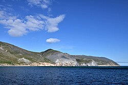
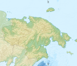
כף דז'נב (ברוסית: мыс Дежнёва, בשפות פלאו-אסיאתיות: Tugnehalha)[1] הייתה ידועה בעבר ככף המזרח וככף ווסטוצ'ני היא הנקודה המזרחית ביותר באסיה וגבולו המזרחי של חצי האי הצ'וקצ'י. הכף ממוקמת במחוז האוטונומי צ'וקוטקה שברוסיה, המאוכלס בדלילות. הכף ממוקמת בין מיצר ברינג לבין ים צ'וקצ'י. בין כף דז'נב לכף הנסיך מוויילס באלסקה, ארצות הברית, מפרידים 82 קילומטרים וביניהן איי דיומיד וסלע פיירווי.[2]

סקירה כללית
ב-1898 קיבלה הכף את שמה, כף דז'נב, שהחליף את השם "כף המזרח" שנתן לה ג'יימס קוק. הכף קיבלה את שמה על מנת להוקיר את מורשתו של סמיון דז'נב, האירופאי הראשון שהגיע למקום (בשנת 1648). לכבודו של דז'נב קיים מגדלור גדול על חוף הים בכף דז'נב.
הכף היא הקצה המזרחי של אזור גבוה וסלעי. מיקומו הגאוגרפי של האזור עזר לו להפוך לנקודת סחר משמעותית בין ציידי הלווייתנים האמריקאים ובני העם הצ'וקצ'י בסוף המאה התשע עשרה ותחילת המאה העשרים.
במקום התקיים בעבר מקום יישוב בשם נאוקן, בו חיו בני עם באותו השם. היישוב ננטש וניתן להבחין בשרידים שלו באזור הכף. רוב תושבי המקום עברו להתגורר בקרבת מקום, בעיר לאוורנטייה שנמצאת גם היא על חופו של חצי האי הצ'וקצ'י, קילומטרים אחדים דרומה מכף דז'נב.
מרחק המעגל הגדול שבין כף דז'נב (צפון-מזרח) לחוף באב אל-מנדב (דרום-מערב) בתימן הוא 10,855 קילומטרים, זהו המרחק הגדול ביותר שניתן לעבור באסיה מבלי לעזוב את היבשת עצמה.
בסיפורו של קורנליוס רוסט שנכתב על ידי ג'וזף מרטין באואר ב-1955, "So weit die Füße tragen" (רחוק עד כמה שרגליי יצליחו להגיע) הוא מספר על בריחה ממחנה מעצר בכף כשבוי גרמני במלחמת העולם השנייה. אמיתות סיפוריו מוטלת בספק מכיוון שאין ממצאים המעידים על קיומו של מחנה כזה בכף אי פעם.[3] בשנת 2001 עובד הספר לכדי הסרט "רחוק ככל שישאו הרגליים".
לקריאה נוספת
- Bartlett, Robert A and Hale, Ralph T. (1916). The last voyage of the Karluk : flagship of Vilhjalmar Stefansson's Canadian Arctic Expedition of 1913-16. McClelland, Toronto.
{{cite book}}: תחזוקה - ציטוט: multiple names: authors list (link). - Bockstoce, John R. (2009) Furs and Frontiers in the Far North: The Contest Among Native and Foreign Nations for the Bering Strait Fur Trade The Lamar Series in Western History, Yale University Press, מסת"ב 0-300-14921-2, מסת"ב 978-0-300-14921-0
- Cochran, C.S. (1915). "Report of northern cruise, Coast Guard cutter Bear". Annual report of the United States Coast Guard. Washington: Government Printing Office. p. 82.
- Crow, John, Anastasia Yarzuktina, and Oksana Kolomiets "American traders and the native people of Chukotka in the early 20th Century" 2010 International Conference on Russian America, Sitka, AK August 18–22.
- Fisher, Raymond H. (ed) (1981) The Voyage of Semen Dezhnev in 1648: Bering's precursor, with selected documents. Hakluyt Society, London.
- Hodge, Frederick Webb (1912) Handbook of American Indians North of Mexico: A-M Volume 30 of Bulletin (Smithsonian Institution. Bureau of American Ethnology). Part 1 of Handbook of American Indians North of Mexico. (Hodge placed Enmitahin north of East Cape, contrary to the location on the USCGS chart. He reports 48 residents in 8 houses, c. 1895, citing Bogoras).
- Krauss, Michael E. (2005) Eskimo languages in Asia, 1791 on, and the Wrangel Island-Point Hope connection Études/Inuit/Studies, vol. 29 (1-2), 2005, pp 163–185.
- Krupnik, Igor and Mikhail Chlenov (2007). "The end of 'Eskimo land': Yupik relocation in Chukotka, 1958-1959" Études/Inuit/Studies 31 (1-2) pp 59–81.
- Office of Coast Survey. "Bering Sea nautical charts". Historical map and chart project. Office of Coast Survey, NOAA, USA. Query Bering; select preview for year wanted. Click desired location to enlarge and center.
- Petit Fute (2006). Chukotka. Avant Garde, Moscow. מסת"ב 5863942584, מסת"ב 978-5-86394-258-2.
- Rasmussen, Knud. Across Arctic America: Narrative of the Fifth Thule Expedition. New York: G. P. Putnam's Sons, 1927. Scanned, illustrated, at Internet Archive.
- Scull, Edward Marshall (1914). Hunting in the Arctic and Alaska. John C. Winston co.
- United States Hydrographic Office (1909). Asiatic pilot, Volume 1. Issues 122-126; Issue 162 of H.O. pub. Gov. Printing Off., Washington.
קישורים חיצוניים
- להמשך קריאה על הכף באתר סילבר-סי
הערות שוליים
- ↑ Leontiev V.V., Novikova K.A. Toponymic Dictionary of the North-East of the USSR / scientific. ed. G. A. Menovschikov ; FEB AN USSR . North-East complex. Research institutes. Lab archeology, history and ethnography. - Magadan: Magad. Prince Publishing House, 1989 .-- p. 130 . - מסת"ב 5-7581-0044-7
- ↑ Cape Dezhnyov, Great Soviet Encyclopedia - Dezhnev Cape, vol. 8, page 25
- ↑ "As far as your feet will cary you - A global hit - Fiction and Truth (A four-tape-interview as the basis for the novel)". Bayerischer Rundfunk (Bavarian Broadcasting Company). 2010-03-23. אורכב מ-המקור ב-20 באוקטובר 2010. נבדק ב-23 בדצמבר 2011.
{{cite web}}: (עזרה)
כף דז'נב30369471


