

משתמש:הדייג/חרבת א-תבנה
 | |
| היסטוריה | |
|---|---|
| תרבויות | כנענים, יהודים, רומים |
| נבנה | התקופה הכנענית בארץ ישראל |
| מיקום | |
| קואורדינטות | 31°41′36″N 35°02′44″E / 31.69333°N 35.04556°E |
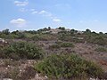
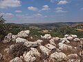
ח'ירבת א-תבנה היא חורבה בשמורת סנסן שבהרי יהודה, בגבעה סמוכה לעמק האלה, כ-3 קילומטרים מזרחית למושב אביעזר וכ-7 קילומטרים דרום-מזרחית לבית נטיף. 622 מטרים (2,041 רגל) מעל פני הים. האתר מזוהה עם העיר המקראית תמנה. הדעות חלוקות לגבי איזו מן הערים המקראיות המכונות תמנה מתייחס הזיהוי[1][2][3].
אטימולוגיה
המזרחן שארל קלרמון גאנו זיהה את המקום עם תמנה, בשל השם הערבי ששימר את השם העתיק של העיר. למרות שלמילה תבנה ישנה גם משמעות בערבית (קש קצוץ)[4]. גם חוקר המקרא וארץ ישראל אדוארד רובינסון סבור כך[5]. גם קלוד קונדר זיהה את האתר כתמנה, והעיר כי התחלפות האותיות ב' ומ' נפוצה מאד בערבית[6][7].
זיהוי
ברשימות הערים שבספר יהושע מופיעים שני אתרים בנחלת שבט יהודה הנקראים תמנה[8]. האחד באזור בית שמש[9], והשני[10] כתוב לצד שמה של גבעה, עיר שנחשבת לג'בעה[11][12]. בתלמוד הירושלמי [13] מובא: "אמר רב: שתי תמנתות היו; אחת מוזכרת בקשר ליהודה, והשנייה מוזכרת בקשר לשמשון ". [14] פרשנים תלמודיים הסבירו כי שמשון, שחי בעיר צרעה שבראש ההר ליד בית שמש, נאמר כי "ירד" לתמנת, [15] אך יהודה נאמר כי "עלה" לתמנת[16] ח. א-טיבנה נחשבת לתמנת המוזכרת בקשר ליהודה ותמר (בראשית לח: 13, 14), [17] [18] [19] [20] אם כי דעה זו נותרה אינה חד משמעית. [8] [21].
בסוף המאה ה-19 נחקרה ח'ירבת א-תבנה על ידי חוקרי הקרן לחקר ארץ ישראל, קלוד קונדר והוריישו קיצ'נר. הם זיהו אותה כתמנה המופיעה בספר יהושע[22] ליד "גבעה", היא ג'בע. את תמנה שליד בית שמש, המופיעה שם בפסוקים הסמוכים[23], זיהו עם תל בטש[24]. לעומתם, ראה יהודה קיל את שתי הערים המוזכרות ביהושע כעיר אחת, היא תמנה המופיעה במעשה יהודה ותמר, וזיהה אותה בחרבת תמנה של ימינו[25].
חוקרים אחרים אינם בטוחים בזיהוי, מכיוון שהאתר טרם נחפר במלואו[26] [27].
תמנה מזוהה גם עם "תפונה" מוזכרת גם ברשימת תחותמס השלישי[28].
הארכיאולוג הישראלי מיכאל אבי-יונה סבור גם שהאתר היה התמנה (תמנתה) המוזכרת במכבים א' (9:50-52[דרושה הבהרה]) ומאוחר יותר הוזכרה על ידי יוסף בן מתתיהו בספר קדמוניות היהודים 13,1,3[דרושה הבהרה], אחד מכמה מקומות שבוצרו על ידי בקכידס בסביבות שם הקודש[דרושה הבהרה]. 160 לפנה"ס לאחר מותו של יהודה המכבי[29] אחרים מציעים שהתיאור בספר מקבים עשוי להתייחס לתמנה אחרת (תמנע), שנקראה ח'ירבת תבנה בדרום מערב שומרון בהר אפרים, כ 14 קילומטרים (8.7 מיל) צפונית-מערבית לבית אל . [30] [31].
מקובל באופן כללי כי התנא שמעון התימני נולד וגדל באחת משתי התמנתות בסוף תקופת בית שני.
ארכיאולוגיה
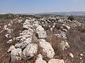
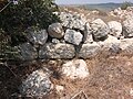
חרבת תבנה ממוקמת על רכס הרים גבוה, כ-2 קילומטרים מערבית לח'ירבת סנאסין, 7 קילומטרים (4.3 מיל) צפונית מזרחית לעדולם.[3] באתר נמצאים שרידיו של מבצר מתקופת הברזל, בעל צורה ריבועית, אשר ככל הנראה הגן על הדרך מעמק האלה לביתר ולירושלים[32], באתר השתמרו שני קירות עשויים אבן גוויל ואבן גזית, שחללים בהם מולאו באבנים קטנות[32]. עמיחי מזר הציע שהמבנה שימש כמבצר או כמרכז מנהלי, ואויש על ידי חיל מצב לאבטחת הכבישים בין הערים הגדולות בשפלה לבין ישובי ההר[33].
התל זרוע הרס רב. בצדו המזרחי שיפוע תלול, היורד אל נחל תבנה, שקצת דרומה משם מתחבר לנחל עציונה. בסמיכות לתל שני בורות מים עתיקים[32].
נכון לשנת 2018, האתר בח'ירבת תבנה טרם נחפר[34]. האתר נסקר על ידי דני וייס, בועז זיסו וגדעון סולימני מרשות העתיקות. הם גילו קטע מדרך עתיקה, שאורכו 200 מטר ורוחבו 2.5 מטר[35]. באתר נמצאו גם חרסים מסוף תקופת הברזל ה-II[36].
ראו גם
גלריה
-
 ח'ירבת א-תבנה
 -
 חומות תמנה
 -
 חורבות כלליות
 -
 תמנה
תמנה -
 ח'ירבת א-תיבנה
 -
 שרידי חומה עבה בח'ירבת א-תיבנה
 -
 חורבת תמנה
 -
 אתר בח'ירבת א-תיבנה
 -
 אבן בח'ירבת א-תבנה
 -
 חומה עבה בחורבת תמנה
 -
 שלוש אבני יסוד
 -
 מבט צפונה מהחורבה
 -
 מבט דרומה
 -
 מבנה מוקף חומה


.jpg)
.jpg)


ביבליוגרפיה
- Abel, F.M. (1938). Géographie de la Palestine (בצרפתית). Vol. 2. Paris: Gabalda.
- Avi-Yonah, M. (1963). Historical Geography of Palestine. Jerusalem: Bialik Institute.
- Avi-Yonah, M. (1976). Gazetteer of Roman Palestine, Qedem - Monographs of the Institute of Archaeology [5] (באנגלית). Vol. 2. Jerusalem: Hebrew University of Jerusalem.
- Avi-Yonah, M. (1977). The Holy Land from the Persian to the Arab Conquests (536 B.C. to A.D. 640) – A Historical Geography. Grand Rapids. ISBN 978-0801000102.
- Clermont-Ganneau, C. (1875), The Site of the City of Adullam, Palestine Exploration Fund Quarterly Statement 7.3 (July), pp. 168–177
- Clermont-Ganneau, C.S. (1896). Archaeological Researches in Palestine During the Years 1873–1874. Vol. 2. London: Palestine Exploration Fund.
- Conder, C.R.; Kitchener, H.H. (1883). The Survey of Western Palestine: Memoirs of the Topography, Orography, Hydrography, and Archaeology. Vol. 3. London: Committee of the Palestine Exploration Fund.
- Emerton, J.A. (1975). "Some Problems in Genesis XXXVIII". Vetus Testamentum (באנגלית). 25 (2): 338–361. doi:10.2307/1516950. JSTOR 1516950.
- Freedman, D.N.; Myers, Allen C. (31 בדצמבר 2000). Eerdmans Dictionary of the Bible. Amsterdam University Press. ISBN 978-90-5356-503-2.
{{cite book}}: (עזרה) - Gibson; Negev, eds. (2001), Archaeological Encyclopedia of the Holy Land, New York / London, ISBN 0-8264-1316-1
- Guérin, V. (1869). Description Géographique Historique et Archéologique de la Palestine (בצרפתית). Vol. 1: Judee, pt. 2. Paris: L'Imprimerie Nationale.
- Kallai, Zechariah (1960). Northern Boundaries of Judah, from the Settlement of the Tribes Until the Beginning of the Hasmonaean Period. Jerusalem.
- Kelm, G.L.; Mazar, A. (1984). "Timnah: A Biblical City in the Sorek Valley". Archaeology. 37 (3): 58–59, 78–79. JSTOR 41729127.
- Klein, S. (1922). Eretz Yisrael: Geography of Israel for High Schools and for the People. Vienna: Menorah.
- Klein, S. (1939). Eretz Yehudah (The Land of Judah). Tel-Aviv. (Hebrew)
- Mazar, A. (1981). "The Excavations of Khirbet Abu et-Twain and the System of Iron Age Fortresses in Judah". Eretz-Israel. 15.
- Mazar, A. (1993), "Abu Tuwein, Khirbet", in Stern, E. (ed.), The New Encyclopedia of Archaeological Excavations in the Holy Land, vol. 1, Jerusalem: Israel Exploration Society, ISBN 965-220-209-6
- McGarvey, J.W. (2002). Lands of the Bible: A Geographical and Topographical Description of Palestine, with Letters of Travel in Egypt, Syria, Asia Minor, and Greece. Adamant Media Corporation. ISBN 978-1-4021-9277-7.
- Meltzer, Muli, ed. (2000), Encyclopaedia Mapa - A Comprehensive Gazetteer of Israel Today, vol. 7, Tel-Aviv, ISBN 965-7009-92-8 (הדייג/חרבת א-תבנה, באתר OCLC (באנגלית)) (Hebrew)
- Neubauer, A. (1868). Géographie du Talmud (בצרפתית). Paris: Michel Lévy Frères.
- Palmer, E. H. (1881). The Survey of Western Palestine: Arabic and English Name Lists Collected During the Survey by Lieutenants Conder and Kitchener, R. E. Transliterated and Explained by E.H. Palmer. Committee of the Palestine Exploration Fund.
- Press, I., ed. (1955), "תמנה א", A Topographical-Historical Encyclopaedia of Palestine, vol. 4, Jerusalem: Rubin Mass, p. 974
- Rainey, A.F. (1983). "The Biblical Shephelah of Judah". Bulletin of the American Schools of Oriental Research (באנגלית). The University of Chicago Press on behalf of The American Schools of Oriental Research. 251 (251): 1–22. doi:10.2307/1356823. JSTOR 1356823.
- Robinson, Edward; Smith, Eli (1841). Biblical Researches in Palestine, Mount Sinai and Arabia Petraea: A Journal of Travels in the year 1838. Vol. 2. Boston: Crocker & Brewster.
- Robinson, E.; Smith, E. (1860). Biblical Researches in Palestine and in the Adjacent Regions: A Journal of Travels in the year 1838. Vol. 2. Boston: Crocker & Brewster.
- Schürer, E. (1891). Geschichte des jüdischen Volkes im Zeitalter Jesu Christi [A History of the Jewish People in the Time of Jesus Christ] (באנגלית). Vol. 1. תורגם ע"י Miss Taylor. New York: Charles Scribner's Sons. pp. 158–159 (note 438).
- Tristram, H.B. (1897). Bible Places: Or, The Topography of the Holy Land: a Succinct Account of All the Places, Rivers, and Mountains of the Land of Israel. London.
קישורים חיצוניים
סקר ארץ ישראל המערבית, מפה משנת 1880, מפה 17: רשות העתיקות, ויקימדיה.
הערות שוליים
- ↑ Clermont-Ganneau (1875), p. 169.
- ↑ Rainey (1983), p. 5.
- ^ 3.0 3.1 Emerton (1975), p. 344.
- ↑ Clermont-Ganneau (1896).
- ↑ Edward Robinson, Biblical researches in Palestine, and in the adjacent regions : a journal of travels in the year 1838, Boston : Crocker and Brewster, 1860.
- ↑ John W. McGarvey, Lands of the Bible: A Geographical and Topographical Description of Palestine, with Letters of Travel in Egypt, Syria, Asia Minor, and Greece, Adegi Graphics LLC, 2002-01, מסת"ב 978-1-4021-9277-7. (באנגלית).
- ↑ C. R. (Claude Reignier) Conder, Palestine Exploration Fund, Horatio Herbert Kitchener Kitchener, Edward Henry Palmer, The survey of Western Palestine : Arabic and English name lists collected during the survey, London : Committee of the Palestine Exploration Fund, 1881.
- ^ 8.0 8.1 Encyclopaedia Judaica (vol. 15), Jerusalem 1971, p. 1147 (s.v. Timnah).
- ↑ ספר יהושע, פרק ט"ו, פסוק י'
- ↑ ספר יהושע, פרק ט"ו, פסוק נ"ז
- ↑ An opinion expressed by historical geographer Klein, S. (1939), p. 198, and by PEF explorers Conder and Kitchener (SWP, III, 53). Jab'a, southeast of Bayt Nattif, is not far situated from Khirbet et-Tibbaneh.
- ↑ Edward Robinson, Biblical researches in Palestine, Mount Sinai and Arabia Petraea. A journal of travels in the year 1838, Boston, Crocker & Brewster, 1841.
- ↑ תלמוד ירושלמי, מסכת סוטה, פרק א', הלכה ח'
- ↑ Same quote cited in Midrash Rabba (Genesis Rabba § 85 and Numbers Rabba 9:24) and in the Babylonian Talmud (Sotah 10a). The 14th-century Midrash Hagadol brings down this tradition under a variant name: "Rebbe has said," etc., instead of "Rav has said.".
- ↑ Judges 14:1.
- ↑ "Genesis 38:13". אורכב מ-המקור ב-2023-10-13..
- ↑ Kelm & Mazar (1984), p. 58.
- ↑ Abel, F.M. (1938), p. 481, s.v. Thimna (1), citing Conder & Kitchener's SWP, III, p. 53.
- ↑ Klein, S. (1922), p. 42.
- ↑ Avi-Yonah (1976), p. 100.
- ↑ H. B. (Henry Baker) Tristram, Bible places, or the topography of the Holy Land; a succinct account of all the places, rivers and mountains of the land of Israel, mentioned in the Bible, so far as they have been identified, together with their modern names and historical references, London, S.P.C.K., 1897.
- ↑ ספר יהושע, פרק ט"ו, פסוק נ"ז
- ↑ פסוק י'
- ↑ Conder & Kitchener (1883), p. 53.
- ↑ דעת מקרא לספר יהושע ט"ו י' וט"ו נז
- ↑ Gibson & Negev (2001), p. 509 [s.v. Timnah (c)].
- ↑ A history of the Jewish people in the time of Jesus Christ / by Emil Schürer Div.2:v.1., HathiTrust (באנגלית).
- ↑ Tristram, Henry Baker (1897), p. 83.
- ↑ Avi-Yonah, Michael (1963), p. 37 (note 7); Avi-Yonah, M. (1977), p. 53. (I. Roll agrees to this view. See: I Roll, "Bacchides' Fortifications and the Arteries of Traffic to Jerusalem in the Hellenistic Period", Eretz-Israel 25 (1996, pp. 509–514 [Hebrew]); Avi-Yonah, M. (1976), p. 100.
- ↑ Kallai, Z. (1960), p. 96.
- ↑ Freedman, D.N. et al. (2000), p. 1312.
- ^ 32.0 32.1 32.2 Meltzer, M. (2000), p. 213.
- ↑ Mazar, A. (1993), p. 16.
- ↑ Israeli archaeologist, Ze'ev Safrai, Correspondence.
- ↑ The Archaeological Survey of Israel; Site No.: 186, Kh. et-Tabbana.
- ↑ Mazar, Amihai (1981), p. 246.
קטגוריה:התקופה העתיקה בארץ ישראל קטגוריה:יישובי המקרא קטגוריה:יישובים ישראליים לשעבר קטגוריה:יהודה: ערים קטגוריה:תלים עתיקים
